Shows
“A Necessary Fiction: Maps, Art, and Models of Our World” at Venice’s Abbazia di San Gregorio

A Necessary Fiction: Maps, Art, and Models of Our World
Abbazia di San Gregorio
Venice
May 6–Nov 22, 2026
Life is too short to be spent on things one suffers through (except maybe for unconditional love). There are days I force myself to go through many things (who doesn’t; it’s called adulting), but the collateral exhibition “A Necessary Fiction,” commissioned by the Saudi Ministry of Culture at the Venice Biennale, is thoroughly a delight to stumble upon. It encapsulates our perception and projection of the world vertically, horizontally, and at times spiritually and fantastically, within the physical space of a 15th-century Benedictine abbey.
Next to the Salute stop of the vaporetto on the Grand Canal, cutouts of colorful half-human, half-animal creatures stand and crawl on the façade, framed by the ornate paline, as if welcoming visitors. This is The Children of Smokeless Fire (2025) by Monira Al Qadiri, which references the illustrations accompanying the 13th-century manuscript The Wonders of Creation and the Oddities of Existence by Persian cosmographer Zakariya al-Qazwini, chronicling a time where mystical and earthly beings coexisted—an Islamic counterpart to the Classic of Mountains and Seas in China and the Roman Empire’s Natural History by Pliny the Elder. Here, Djinns, the Islamic hybrid beings born from smokeless fires and residing in a parallel universe, become guides to visitors traversing an exhibition on maps—itself an atlas of the real, the fictional, and the metaphorical.

The exhibition cannot be better situated; after all, Venice was once the point connecting Europe to the rest of the world. The likes of Marco Polo couldn’t possibly have traveled without a map, a guide, or some form of navigation system. A sequence of Arab empires—known in Chinese historical records by the white, black, and green of their clothes—Umayyad Caliphate (661–750 CE), Abbasid Caliphate (750–1258 CE), and Fatimid Caliphate (909–1171 CE)—controlled much of Central and West Asia, and connected East and South Asia with Europe and Africa through trade and wars. The Battle of Talas (751 CE) has been construed as how papermaking transferred from China to Europe via the Abbasids, as the Tang and Arab empires collided and Tang prisoners of war—skilled craftsmen—carried technological knowledge coveted in the West. The works on display range from the very ancient to the very new, while the lenders to the exhibition, in addition to the Saudi National Museum, the King Abdulaziz Public Library and archive, include Yale University, the Bodleian of Oxford, and Leiden University, among other historic and national libraries in the old and Arab worlds.
It’s a pity the exhibition does not include the 14th-century Catalan Atlas at the Bibliothèque nationale de France (it is reproduced in one of the books on display), the Mao Kun map that shows the navigation charts used by the Chinese Muslim admiral Zheng He (1371–1433), which includes instructions from Hormuz to Calicut, or the 1602 Kunyu Wanguo Quantu—the earliest Chinese world map using European cartography, created by the Italian Jesuit missionary Matteo Ricci and his Chinese collaborators, with one copy held in the Vatican Library—all of which would have fit the exhibition’s parameters quite well. That said, the amount and range of works “A Necessary Fiction” does present are very rich and fascinating. In the first gallery, the floor is covered by a carpet woven with the digital reconstruction of the 13th-century Ebstorf Map that was destroyed in Allied bombings. A typical medieval map, it represents Afro-Eurasian landmass as a circle divided by a T-shaped body of water (the Mediterranean Sea, the Greek river Don, and the Nile). The complex histories, ideologies, projections, and religions that shape any worldview are condensed into this one map under our feet, and it sets the tone for the exhibition. In the same room are many types of real and imaginary maps, printed and collected in various volumes. I particularly loved one titled “I wisely started with a map…”—a celebration of fictional cartography published by Daniel Crouch Rare Books. The book includes maps of Hell—never thought I would need one, thank you for thinking ahead—drawn by scholars and artists following Dante’s text. Of all the imaginary maps, my favorite would have to be a map of The Hundred Acre Wood, where Winnie-the-Pooh and other stuffed animals live, illustrated by E. H. Shepard (1879–1976).
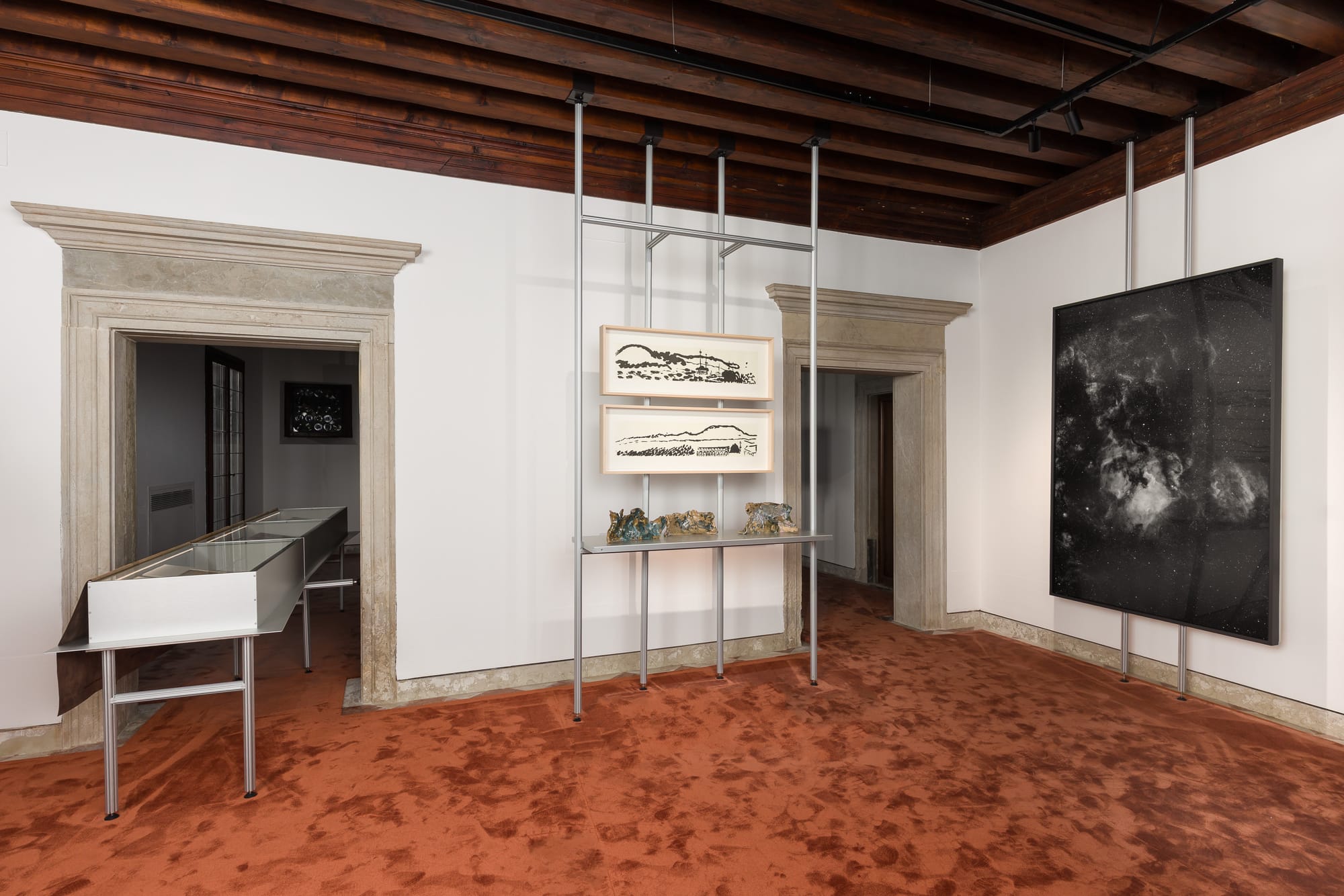
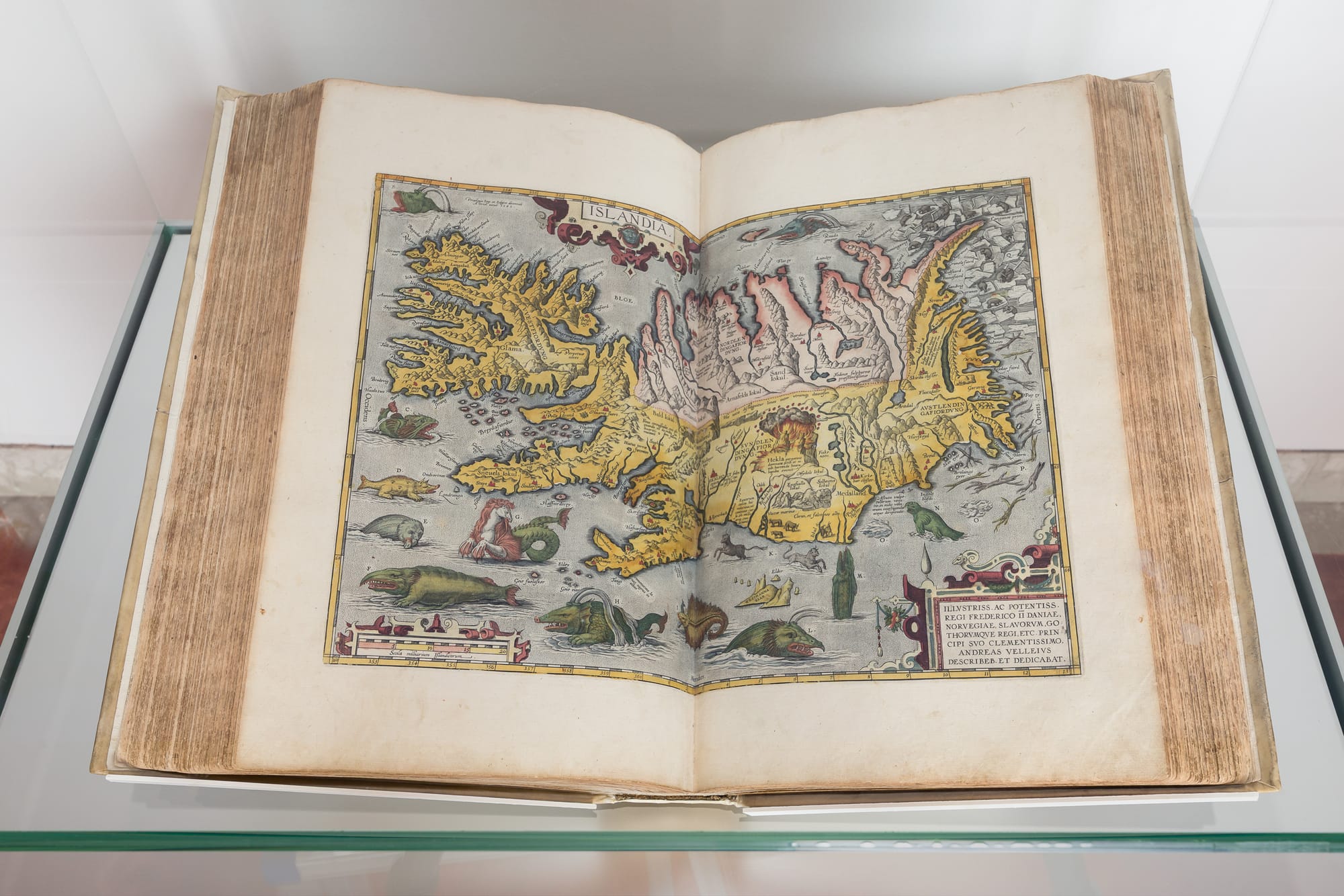
Installation view (left) and detail of ABRAHAM ORTELIUS’s Theatrum Orbis Terrarum, 1595 (right), at “A Necessary Fiction: Maps, Art, and Models of Our World,” Abbazia di San Gregorio, Venice, 2026. Photos by Mark Blower. Copyright and courtesy the Saudi Ministry of Culture.
While “A Necessary Fiction” is largely a contemporary art exhibition, the connections it draw with its wonderful selection of historical maps are food for thought. The ingeniously designed caseworks extend across rooms through doorways, connecting spaces in new ways—as the maps they exhibit do—while protecting the fragile manuscripts (some are facsimiles), with built-in magnifying glasses that are very satisfying to operate by sliding on tracks. There are illustrated maps and zodiacs to accompany al-Qazwini’s Wonders of Creation across the continent. From the same early-modern period, there are lots of incredible monsters in faraway lands and seas. I loved Abraham Ortelius’s Islandia from Theatrum Orbis Terrarum, published in Antwerp in 1595. It shows an island surrounded by waters teeming with all the medieval sea monsters I learned about as a child, including the half-horse, half-dragon hippocampus (not the brain’s memory center) and other grotesque monster-whales.
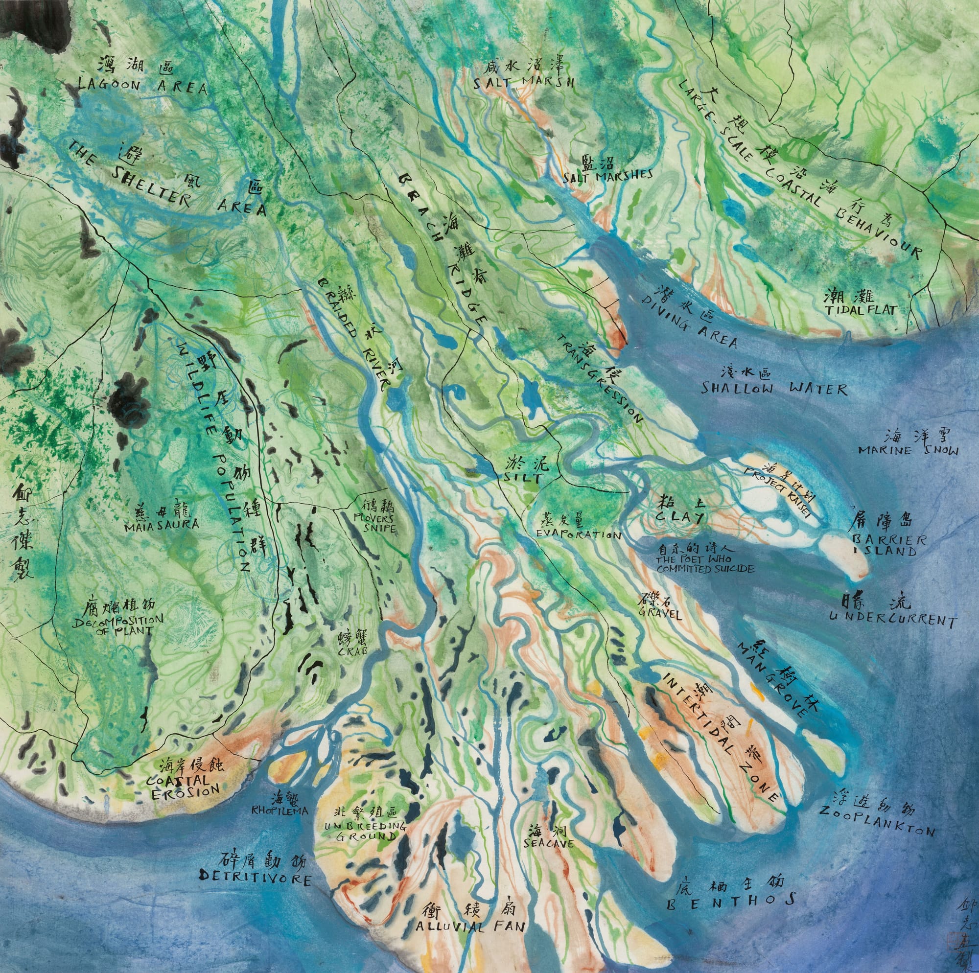
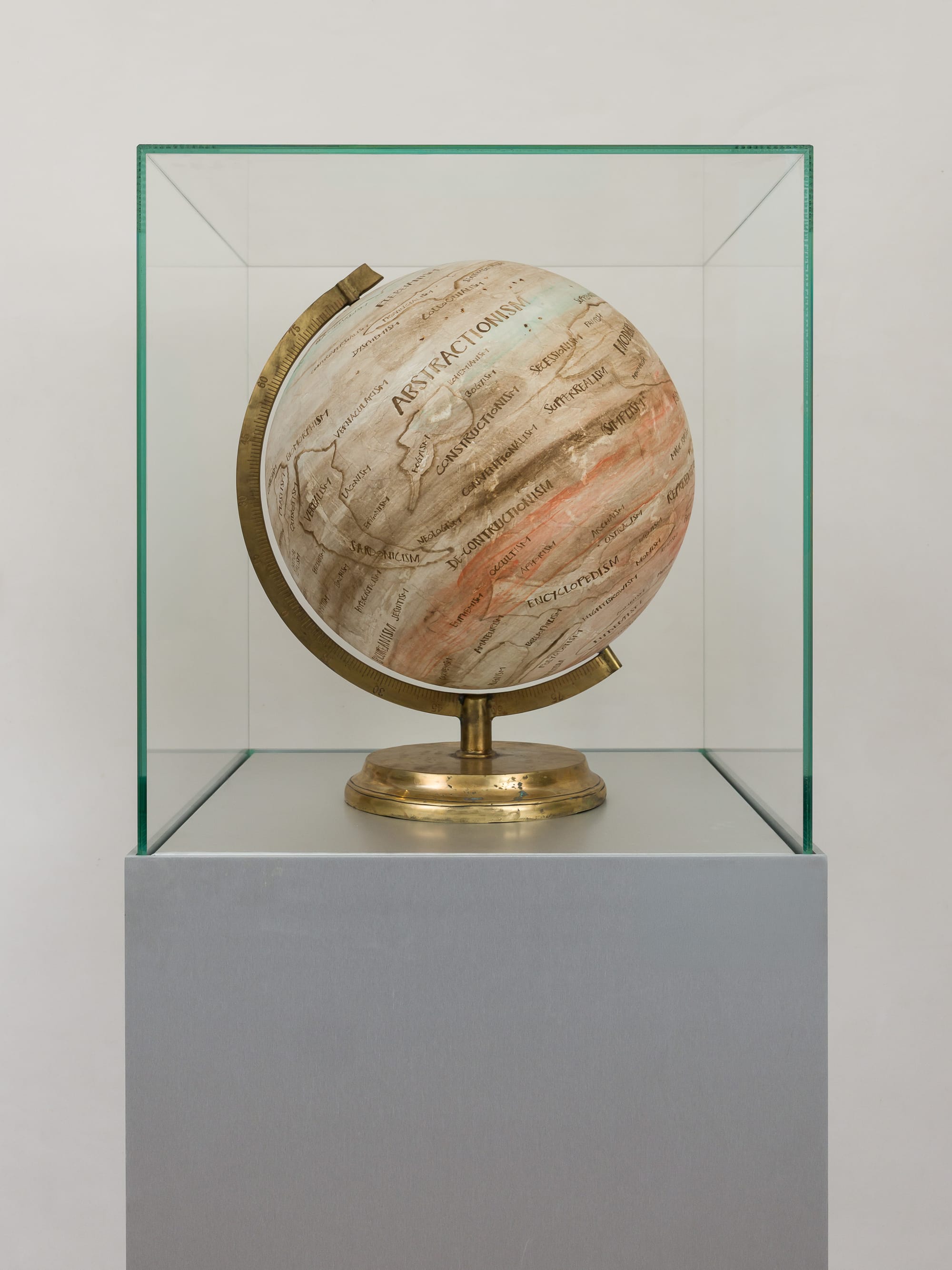
QIU ZHIJIE, Battle of Cochin, 2023, ink on paper, framed on stretcher bars, 70 × 70 × 3 cm. Courtesy the artist and GALLERIA CONTINUA (left); and installation view of QIU ZHIJIE’s Tellurian 5: Geography of Interests, 2018, at “A Necessary Fiction: Maps, Art, and Models of Our World,” Abbazia di San Gregorio, Venice, 2026. Photo by Mark Blower. Copyright and courtesy the Saudi Ministry of Culture (right).
The early-modern world had its sciences navigate around powerful religious control, and the curators included a page from the 1561 Ptolemaei Typus, published in Venice and based on the 2nd-century Ptolemy’s geographic theories (that Earth is stationary), with a landlocked Indian Ocean. It might be worth remembering that Copernicus had already published his heliocentric model in 1543. Letting go of one’s beliefs, whatever they might be, is indeed very scary. It’s not surprising to see two works by Qiu Zhijie from his Mappa Mundi series; Battle of Cochin (2023) is geological, with terms like “Coastal Erosion” and “Alluvial Fan” marked alongside “Plovers Snipe” and “Maiasaura.” The globe Tellurian 5: Geography of Interests (2018) includes his signature map of ideologies: occultism, magic realism, sardonicism, materialism, and so on. Maps here don’t quite represent the physical world but mirror mindscapes.
Reena Saini Kallat’s Woven Chronicle (2011– ) cuts a little deeper, displaying the migration routes taken by various groups of people, made with electric cables but visually recalling barbed wire. Who gets to move around freely in the world, and who is forced to leave their home? It draws an interesting comparison with The Whole Internet (1999), Peacock Maps’s visual data map displayed inside a wall cupboard on a different floor, with a 1986 London Underground map based on Henry C. Beck’s 1933 design. The former is a visual presentation of the Internet’s structure pre-Y2K, focusing on the interconnections between different networks across the globe, as the Internet was rapidly expanding outside academia and the corporate world and seeping into everyday life. I would like to see Kallat’s map superimposed over the Internet map, and perhaps further compared with the Submarine Cable Map, which reveals how information travels through the undersea network connecting continents. The better connected a place is, the higher its hierarchy in global politics and economy. It would have been nice to see the 1980s London Underground map juxtaposed with either the current one or with another major city known for its commuter network, like Tokyo, New York, or Paris. The New York subway map has recently been “updated” to resemble a 1970s design that was never used, one that prioritized legibility through modernist, streamlined graphics, as opposed to the edition of the last 50 years that insisted on the “reality” of shapes of the five boroughs.
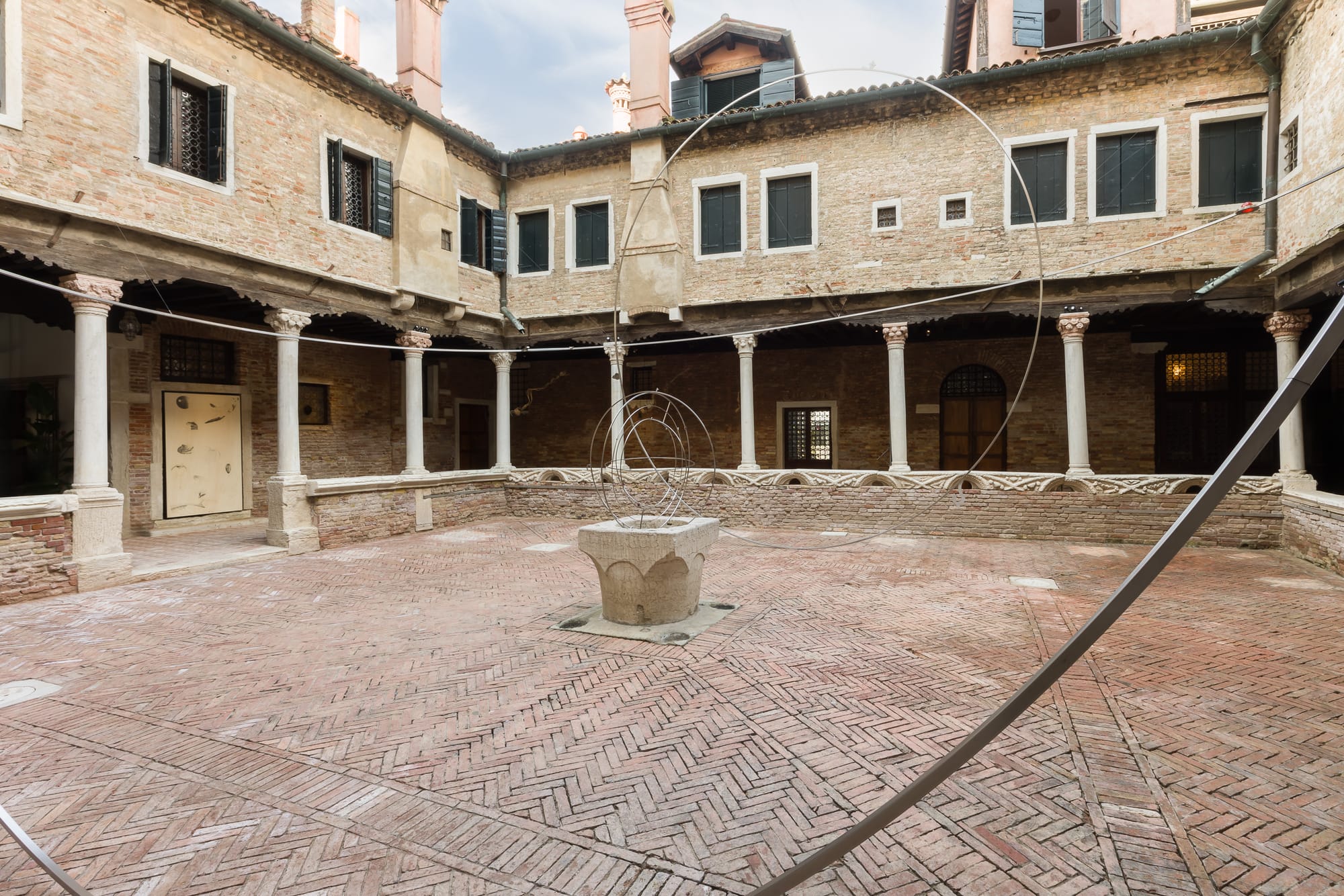
In the courtyard of the abbey, writer Tod Wodicka and sound artist Abdullah Miniawy paired up for a site-specific soundscape commission titled Sonic Psychogeography (2026), which draws on the world of fiction—itself sometimes an act of constructing a universe—and associates it with tonal qualities. The experience was slightly confusing, as what one sees is the installation Each Time a Star Goes Astray (2026) by Nasser Al Salem, also a site-specific commission that resembles circles marking out the space in the courtyard, and it felt more like various cultures’ depiction of the universe, like orbits of adjacent galaxies. Together, the two works felt like astronomers (or astrologers, given the colored Murano glass inlaid at strategic points on each circle) charting their interstellar course—probably a fitting interpretation. So much of historical cartography lacks accuracy, and our ancestors lived without satellite technology. They couldn’t see from a bird’s-eye—or God’s-eye—view of where they stood within a larger context, and it would have taken great courage and adventurousness to explore unknown lands, learn to record new territories, and pass along that knowledge to those who come after. Both literature and music exist in time, as narratives unfold and chords progress, just as paths from point A to point B must be traversed. The exhibition ends with two Map Pieces by Yoko Ono. The 1962 instructions eventually tell us to “Give your friends maps.” The 1964 one simply asks: “Draw a map to get lost.”
Sometimes one might just be going in circles, getting lost, like Piglet joining his friend Pooh in tracking the mysterious and scary Woozle through the woods. And that’s okay, too.
Kelly Ma is a New York-based curator and writer.